Alteryx Designer Desktop Ideas
Share your Designer Desktop product ideas - we're listening!Submitting an Idea?
Be sure to review our Idea Submission Guidelines for more information!
Submission Guidelines- Community
- :
- Community
- :
- Participate
- :
- Ideas
- :
- Designer Desktop: Top Ideas
Featured Ideas
Hello,
After used the new "Image Recognition Tool" a few days, I think you could improve it :
> by adding the dimensional constraints in front of each of the pre-trained models,
> by adding a true tool to divide the training data correctly (in order to have an equivalent number of images for each of the labels)
> at least, allow the tool to use black & white images (I wanted to test it on the MNIST, but the tool tells me that it necessarily needs RGB images) ?
Question : do you in the future allow the user to choose between CPU or GPU usage ?
In any case, thank you again for this new tool, it is certainly perfectible, but very simple to use, and I sincerely think that it will allow a greater number of people to understand the many use cases made possible thanks to image recognition.
Thank you again
Kévin VANCAPPEL (France ;-))
Thank you again.
Kévin VANCAPPEL
When calculating distance from a single point (or a list of points) to many other points, it can require a lot of processing time to append the single point into the same table as the multiple points (especially with very large datasets). Seems it would be more efficient to allow the single point as in input to the distance tool and bypass the timely append step.
-
Category Spatial
-
Location Intelligence
it would be nice Street Geocoding tool can be capable of accepting Latitude and Longitude and spit out the address like Reverse Geo Coding . The reverse Geo coding currently using TomTom is too slow to process hundred thousands records.. if the data is already local to our system in form of CASS or Street Geocoder that will be certainly faster.
-
Category Spatial
-
Location Intelligence
An ability to modify the angle of the grids created. Degree Angle input would be real simple to use and would allow for creating more appropriate grids without making really small grids and re-merging them for similar result. North South & East West grids are nice, however ability to change to NW by SE would be real nice.

-
Category Spatial
-
Location Intelligence
I'm still relatively new, so I trust someone will correct and instruct me if this already exists. I have looked and have not been able to find it.
It would be nice if there was an option to return the standard 2 letter abbreviations for states from the Allocate Input tool's "Pick Variables" "geographic Identifiers." Currently, the only identifiers available are "Key" an"Name":

Where, Key is numeric ("02", "44", etc.), and Name is the full state Name. In order to join to most of our databases, I usually need this to be the standard 2 letter abbreviation. This forces me to join to another database table to translate it.
-
Category Spatial
-
Location Intelligence
Could you please add a second/separate opacity setting for polygons? Many times I'd like to have a solid border around a trade area, but with about a 50% opacity setting for the fill.
Thanks!
-
Category Reporting
-
Category Spatial
-
Desktop Experience
-
Location Intelligence
Currently, the map input for an application defaults either to a global view of the United States or to a fixed boundary. Usng a chained application, it would be an extremely useful option to be able to specifiy spatial objects (points, lines, polygons) in the first application and then allow the second application to zoom in appropriately to those spatial objects. This could be done by either specifying a custom zoom level and using those spatial objects as a center through a reference layer, or by allowing the zoom's boundary to contain all the spatial objects (similar to the map reporting tools).
-
Category Spatial
-
Location Intelligence
I would like the capability to spatially intersect vector data over raster based geographic information. I have to go back and forth between Alteryx and ArcGIS to perform the zonal statistics and then back to Alteryx to complete the data analysis.
-
Category Spatial
-
Location Intelligence
With more people moving into urban developments, it would be helpful to allow analysts to measure customers within a "walking distance". Similar to drive time analysis, a step up would be to incorporate "walk time" analysis.
-
Category Behavior Analysis
-
Category Data Investigation
-
Category Spatial
-
Desktop Experience
Alteryx's spatial tools are really powerful and offer a lot of value for analysis. However, when rendering a map for output, there is currently no way to place an image inside of a polygon. This feature would be very useful for customized layers on maps and other spatial-based processes.
My rough suggestion would be to scale a selected image to the size of the polygon's bounding rectangle, and then trim the edges of the image to fit inside the polygon itself.
-
Category Reporting
-
Category Spatial
-
Desktop Experience
-
Location Intelligence
-
Category Spatial
-
Location Intelligence
Hello!
I think it would be useful to have an ability to groupby spatialobj in the summarize tool. I currently work around this by using several tools and I think it would be great to use the native summarize tool.
-
Category Spatial
-
Location Intelligence
It would be great to have a spatial function that could be used to evaluate whether two spatial objects are equal/identical. I see this being available in at least three places:
- An "ST_Equal" Formula function
- A SpatialMatch "Where Target Equals Universe"
- An "Equals" Action in the Spatial Process tool
-
Category Data Investigation
-
Category Spatial
-
Desktop Experience
-
Location Intelligence
Working for an education company, it would be a huge value for us to be able to have the US school districts available in the spatial sweet of apps, so I could take all of the US schools that are customers and map them to their School Districts in a polygon map.
-
Category Spatial
-
Location Intelligence
US and Canada datasets are underlined so far but,
Alteryx is expanding towards, Denmark, Germany, France and several other countries...
The question is; Why don't we have Eurostat data provided as well?

Bulk options for some datasets are available.
Even one can get a grasp on micro datasets and Alteryx may have a deal inf this micro dataset is anonymized...


-
Category Address
-
Category Behavior Analysis
-
Category Spatial
-
Category Time Series
I'm plotting ship's routes on a map by using the Poly-Build tool to create a Sequence Polyline, the source field is a daily snapshot of a ship's position, the sequence is the date. This works well until the ship goes off the map, i.e heading west in the North Pacific to Japan. Rather than wrapping the line around the world, it draws an ugly line across the map:

I've seen some super clever WFs on here where people have manipulated coordinates to stop this happening, but rather than me having to do that (and probably getting it wrong), could you make the Poly-Build tool map sensitive?
-
Category Spatial
-
Location Intelligence
Hello all,
It would be awesome if Alteryx was able to accept Lat/Long and be able to tell you what timezone that location was in and be able to do time analysis from there.
Thoughts?
Thanks,
Nick
-
Category Input Output
-
Category Spatial
-
Category Time Series
-
Data Connectors
Do put an option to take any distance.

it sure have case that we do not care the distance.
same go to other spatial tool have similar setting.
-
Category Spatial
-
Location Intelligence
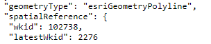
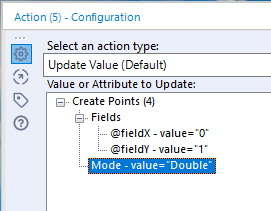
In GIS, spatial data is regularly stored/transmitted as text. With this comes metadata, including the projection used.
Example Issue: When extracting data from ESRI's ArcGIS REST Directories, the projection can be extracted from the information, but must be manually defined in the Make Points Tool. If you are trying to compile data from several different sources, all using different projections, you cannot automate the process.
Suggested Solution: Add WKT to macro interface configuration options so that an Action Interface Tool can update the Create Points Tool.
Attachments:
JSON extract.png - This is a screenshot of the spatial reference metadata in a JSON formatted query from an ArcGIS REST Directory.
action tool.png - Current configuration options for Create Points Tool in the Action Interface Tool.
-
Category Interface
-
Category Macros
-
Category Spatial
-
Desktop Experience
I appreciate being able to write to an ESRI File GeoDatabase. It would be even better if in the process of writing to an ESRI File GeoDatabase I could identify fields to index and have them indexed when writing to the File GeoDatabse. Currently I have to add the index in ArcGIS after the fact. Writing to an ESRI File GeoDatabase currently adds a spatial index automatically, but I'm talking about an attribute index here.
-
Category Input Output
-
Category Spatial
-
Data Connectors
-
Location Intelligence
Alteryx started as a geospatial application. The "y" and "x" in Alteryx stand for the geospatial origin of the application. So why doesn't every tool in the Spatial Category have a One Tool Example? As of version 2019.2.7, there is only one One Tool Example in the Spatial Category. It is for the Distance Tool.
Please make One Tool Examples for every Spatial tool. Thank you.
-
Category Spatial
-
Location Intelligence
- New Idea 259
- Accepting Votes 1,818
- Comments Requested 24
- Under Review 170
- Accepted 56
- Ongoing 5
- Coming Soon 11
- Implemented 481
- Not Planned 118
- Revisit 63
- Partner Dependent 4
- Inactive 674
-
Admin Settings
20 -
AMP Engine
27 -
API
11 -
API SDK
218 -
Category Address
13 -
Category Apps
112 -
Category Behavior Analysis
5 -
Category Calgary
21 -
Category Connectors
245 -
Category Data Investigation
76 -
Category Demographic Analysis
2 -
Category Developer
208 -
Category Documentation
80 -
Category In Database
214 -
Category Input Output
637 -
Category Interface
238 -
Category Join
102 -
Category Machine Learning
3 -
Category Macros
153 -
Category Parse
76 -
Category Predictive
77 -
Category Preparation
392 -
Category Prescriptive
1 -
Category Reporting
198 -
Category Spatial
81 -
Category Text Mining
23 -
Category Time Series
22 -
Category Transform
87 -
Configuration
1 -
Data Connectors
959 -
Data Products
3 -
Desktop Experience
1,525 -
Documentation
64 -
Engine
125 -
Enhancement
317 -
Feature Request
212 -
General
307 -
General Suggestion
4 -
Insights Dataset
2 -
Installation
24 -
Licenses and Activation
15 -
Licensing
12 -
Localization
8 -
Location Intelligence
80 -
Machine Learning
13 -
New Request
188 -
New Tool
32 -
Permissions
1 -
Runtime
28 -
Scheduler
24 -
SDK
10 -
Setup & Configuration
58 -
Tool Improvement
210 -
User Experience Design
165 -
User Settings
78 -
UX
223 -
XML
7
- « Previous
- Next »
- AudreyMcPfe on: Overhaul Management of Server Connections
- rpeswar98 on: Alternative approach to Chained Apps : Ability to ...
-
 caltang
on:
Identify Indent Level
caltang
on:
Identify Indent Level
- simonaubert_bd on: OpenAI connector : ability to choose a non-default...
- maryjdavies on: Lock & Unlock Workflows with Password
- nzp1 on: Easy button to convert Containers to Control Conta...
-
Qiu
on:
Features to know the version of Alteryx Designer D...
- DataNath on: Update Render to allow Excel Sheet Naming
- aatalai on: Applying a PCA model to new data
- charlieepes on: Multi-Fill Tool
| User | Likes Count |
|---|---|
| 27 | |
| 13 | |
| 7 | |
| 6 | |
| 6 |