Weekly Challenges
Solve the challenge, share your solution and summit the ranks of our Community!Also available in | Français | Português | Español | 日本語
IDEAS WANTED
Want to get involved? We're always looking for ideas and content for Weekly Challenges.
SUBMIT YOUR IDEA- Community
- :
- Community
- :
- Learn
- :
- Academy
- :
- Challenges & Quests
- :
- Weekly Challenges
- :
- Re: Challenge #67: Calculate Spatial Angles
Challenge #67: Calculate Spatial Angles
- Subscribe to RSS Feed
- Mark Topic as New
- Mark Topic as Read
- Float this Topic for Current User
- Bookmark
- Subscribe
- Mute
- Printer Friendly Page
- Mark as New
- Bookmark
- Subscribe
- Mute
- Subscribe to RSS Feed
- Permalink
- Notify Moderator
The solution to last week's challenge can be found HERE.
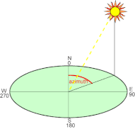
This week, we get back to spatial! A wireless carrier wants to geolocate or triangulate the location of a device/user based on the location of nearby cell towers and the device/user by determining the azimuth. As a result, they would like to calculate the angle (in degrees) between two points where a line is drawn from the lower point directly horizontally towards the other point.
Bonus: Try solving one way with the spatial tools, and another using no spatial tools!
- Mark as New
- Bookmark
- Subscribe
- Mute
- Subscribe to RSS Feed
- Permalink
- Notify Moderator
My solution, two ways - one with spatial tools, one without! :)
PS. Holy trigonometry, I had to dig deep for that one. My high school self is very disappointed with me right now for apparently forgetting everything I once knew about calculating angles...
- Mark as New
- Bookmark
- Subscribe
- Mute
- Subscribe to RSS Feed
- Permalink
- Notify Moderator
I used a couple more tools than @NicoleJohnson to calculate all the distances and angles, but came away with the solution in both formats. Another Masonic image transposed onto the DC landscape :>
- Mark as New
- Bookmark
- Subscribe
- Mute
- Subscribe to RSS Feed
- Permalink
- Notify Moderator
I got to the same answer as @NicoleJohnson, but stopped after getting the right result. I get no dessert.
Cheers,
Mark
Chaos reigns within. Repent, reflect and restart. Order shall return.
Please Subscribe to my youTube channel.
- Mark as New
- Bookmark
- Subscribe
- Mute
- Subscribe to RSS Feed
- Permalink
- Notify Moderator
Oh gosh my way is super hackish and I didnt know how to do the bonus. I've had a look and there are definitely a lot of spatial features I am not familiar with, especially the functions, nice to learn from other's answers.
- Mark as New
- Bookmark
- Subscribe
- Mute
- Subscribe to RSS Feed
- Permalink
- Notify Moderator
So - full credit goes to this site which explained the full math of the great circle distance; provided pseudo code in Java / excel formulas; etc. http://www.movable-type.co.uk/scripts/latlong.html
I fully admit I don't understand the derivation of these formulae, but at least a little smarter now on how to use some of the trig & distance functions in Alteryx
This solution contains both spatial & basic trig version, and the non-spatial calculates both distance and angle fully using trig.
To @NicoleJohnson 's point - who would have ever thought that a subject like "Math" would come in useful one day...
Possibly one-day, I may find a good use for some of the other subjects we did in school like accounting; computer science; Inglish Wrting; etc. :-)
- Mark as New
- Bookmark
- Subscribe
- Mute
- Subscribe to RSS Feed
- Permalink
- Notify Moderator
Hopefully, my spatial solution will count as spatial since I used only one spatial tool.
I also have to admit a trigonometry defeat as I am sure 16 formulas were unnecessary and the answer I got was anyway smaller by ~1,5 degrees. That being sad, my spacial answer is also a bit off but I guess it can be a rounding error.
- Mark as New
- Bookmark
- Subscribe
- Mute
- Subscribe to RSS Feed
- Permalink
- Notify Moderator
The solution for Challenge #67 is posted! I'm sorry if is exacerbated any negative feelings around having to recall some highschool trig for that bonus. :)
- Mark as New
- Bookmark
- Subscribe
- Mute
- Subscribe to RSS Feed
- Permalink
- Notify Moderator
Thanks, JoeM
I see many people use Spatial info before cross tab and distance calculation. Is there any reason for that, as I had the same results without this step?
- Mark as New
- Bookmark
- Subscribe
- Mute
- Subscribe to RSS Feed
- Permalink
- Notify Moderator
-
Advanced
302 -
Apps
27 -
Basic
158 -
Calgary
1 -
Core
157 -
Data Analysis
185 -
Data Cleansing
5 -
Data Investigation
7 -
Data Parsing
14 -
Data Preparation
238 -
Developer
36 -
Difficult
87 -
Expert
16 -
Foundation
13 -
Interface
39 -
Intermediate
268 -
Join
211 -
Macros
62 -
Parse
141 -
Predictive
20 -
Predictive Analysis
14 -
Preparation
272 -
Reporting
55 -
Reporting and Visualization
16 -
Spatial
60 -
Spatial Analysis
52 -
Time Series
1 -
Transform
227
- « Previous
- Next »


