Weekly Challenges
Solve the challenge, share your solution and summit the ranks of our Community!Also available in | Français | Português | Español | 日本語
IDEAS WANTED
Want to get involved? We're always looking for ideas and content for Weekly Challenges.
SUBMIT YOUR IDEA- Community
- :
- Community
- :
- Learn
- :
- Academy
- :
- Challenges & Quests
- :
- Weekly Challenges
- :
- Re: Challenge #70: Trade Area Drivetime Radii
Challenge #70: Trade Area Drivetime Radii
- Subscribe to RSS Feed
- Mark Topic as New
- Mark Topic as Read
- Float this Topic for Current User
- Bookmark
- Subscribe
- Mute
- Printer Friendly Page
- Mark as New
- Bookmark
- Subscribe
- Mute
- Subscribe to RSS Feed
- Permalink
- Notify Moderator
The solution to last week's challenge is HERE!
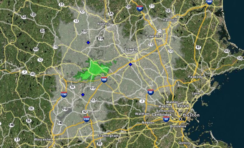
Today we’re challenged to find the total area (square miles) that we can move our company headquarters to such that it is an equidistant commute from 3 satellite offices. In order to do so, find the area that is shared by a 30 minute drive time radius starting from each of the satellite offices!
Be warned! You may arrive on different areas depending on the spatial data release that is used, in addition to the drivetime methodology selected. For the sake of comparison, use the above map as an estimation of the area if you are not using the Q2: 2016 TomTom US Peak Most Recent Vintage dataset. If you think you need a hint, expand the spoiler below!
- Labels:
-
Advanced
-
Basic
-
Spatial
-
Spatial Analysis
-
Transform
- Mark as New
- Bookmark
- Subscribe
- Mute
- Subscribe to RSS Feed
- Permalink
- Notify Moderator
- Mark as New
- Bookmark
- Subscribe
- Mute
- Subscribe to RSS Feed
- Permalink
- Notify Moderator
My (pseudo) solution. I don't have access to drivetime data, so I wasn't able to answer the question exactly as asked... but I can see comparing to @MarqueeCrew 's solution that I have the same process, so barring changing from "miles" to "minutes" if I'd had the drivetime dataset, I believe it's the same. So count this as my "I drew this with a stick in the sand because I didn't have the right tools" solution? :)

- Mark as New
- Bookmark
- Subscribe
- Mute
- Subscribe to RSS Feed
- Permalink
- Notify Moderator
I don't have the spatial package either so I winged it to come up with 2 different areas to consider for the HQ. I used a both spatial tools and spatial formulas to come up with the answers.
2) Using the answer of an area of 30.967 square miles, I backed into a radius (3.14 - just happens to be approx. PI) to create a trade area around the center point.
3) Using midpoints between each point and also midpoints between each point and the center, I created a polygon, but the area was approx 50 square miles.
4) I then created new midpoints between the previous midpoints and the center to make the area smaller and closer to the center. This polygon had an area of 12.64 square miles.


- Mark as New
- Bookmark
- Subscribe
- Mute
- Subscribe to RSS Feed
- Permalink
- Notify Moderator
It is a bit frustrating that the correct solution is available only to the owners of a spatial package. But challenge is a challenge, and I made some driving time assumptions based on the speed limit. My assumptions are a bit bolder than those of NicoleJohnson, but the solution itself is similar.
- Mark as New
- Bookmark
- Subscribe
- Mute
- Subscribe to RSS Feed
- Permalink
- Notify Moderator
For example - I'm wondering if you had something in mind related to punching out to a different API that can do this. IF this is the case - can you give a hint?
:) have a good day Matt
Sean
- Mark as New
- Bookmark
- Subscribe
- Mute
- Subscribe to RSS Feed
- Permalink
- Notify Moderator
Used a similar "stick in the sand" approach as @NicoleJohnson and @Natasha. As Nicole says, it's the same solution as Mark @MarqueeCrew, but using a mile-radius rather than a drive-time radius. Still holding out that @MattD has some sneaky idea up his sleeve for those of us without spatial data packages...
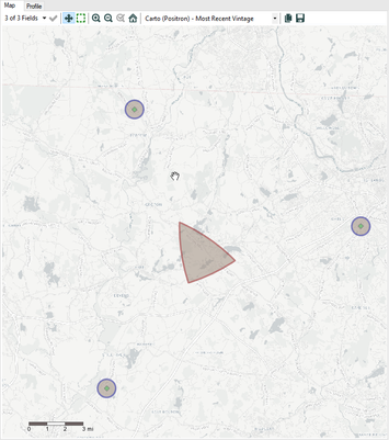
Image below is the final resulting intersection and the original locations of the satellite offices.
- Mark as New
- Bookmark
- Subscribe
- Mute
- Subscribe to RSS Feed
- Permalink
- Notify Moderator
I have an outdated spatial release (getting the update soon), so my numbers are slightly off. This is with 2015 Q3 data.
Map of the overlapping trade area:

My workflow:

- Mark as New
- Bookmark
- Subscribe
- Mute
- Subscribe to RSS Feed
- Permalink
- Notify Moderator
Hey Everyone!
For those of you who do not have the spatial data package, I went ahead and created a macro that uses Google Maps to calculate distance and drivetime between two points or addresses! While you'll still end up with a different total area as compared to the Q2: 2016 TomTom US Peak Most Recent Vintage dataset, this will make it so that you can answer these types of questions in the future without full access to the spatial data package!
- Mark as New
- Bookmark
- Subscribe
- Mute
- Subscribe to RSS Feed
- Permalink
- Notify Moderator
Thank you @MattD!!! You're the best! :)
-
Advanced
301 -
Apps
26 -
Basic
158 -
Calgary
1 -
Core
157 -
Data Analysis
185 -
Data Cleansing
5 -
Data Investigation
7 -
Data Parsing
14 -
Data Preparation
238 -
Developer
36 -
Difficult
86 -
Expert
16 -
Foundation
13 -
Interface
39 -
Intermediate
268 -
Join
211 -
Macros
62 -
Parse
141 -
Predictive
20 -
Predictive Analysis
14 -
Preparation
272 -
Reporting
55 -
Reporting and Visualization
16 -
Spatial
60 -
Spatial Analysis
52 -
Time Series
1 -
Transform
227
- « Previous
- Next »


