Alteryx Designer Desktop Discussions
Find answers, ask questions, and share expertise about Alteryx Designer Desktop and Intelligence Suite.- Community
- :
- Community
- :
- Participate
- :
- Discussions
- :
- Designer Desktop
- :
- Re: Alteryx doesn't plot shapefile properly
Alteryx doesn't plot shapefile properly
- Subscribe to RSS Feed
- Mark Topic as New
- Mark Topic as Read
- Float this Topic for Current User
- Bookmark
- Subscribe
- Mute
- Printer Friendly Page
- Mark as New
- Bookmark
- Subscribe
- Mute
- Subscribe to RSS Feed
- Permalink
- Notify Moderator
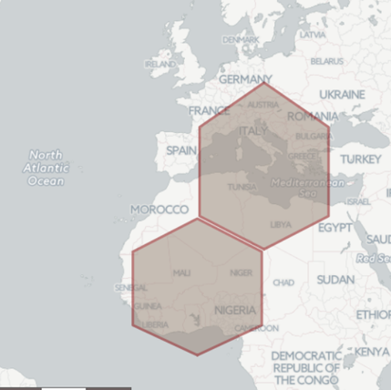
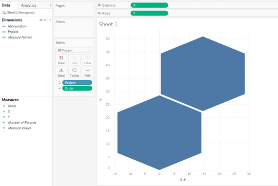
I'm trying to create a hex map using Alteryx. I'm sure my coordinates are correct, but Alteryx stretches one of the hexagons. Any ideas why? I've plotted the same hexagons in Tableau and they look just fine.
Solved! Go to Solution.
- Labels:
-
Spatial Analysis
- Mark as New
- Bookmark
- Subscribe
- Mute
- Subscribe to RSS Feed
- Permalink
- Notify Moderator
Alteryx is treating them as Latitude and Longitude, not cartesian co-ordinates.
If you tell Tableau to treat as Longitude and Latitude it produces exactly the same
- Mark as New
- Bookmark
- Subscribe
- Mute
- Subscribe to RSS Feed
- Permalink
- Notify Moderator
The values of the two objects are the same, but the coordinate plane they are applied to are different. Projecting objects to the oblate spheroid surface of the earth can be tricky. When drawing custom polygons and calculating coordinate positions, degrees of latitude are pretty consistent, but lengths of longitude vary by the latitude.
Here's a good link on calculating linear lengths of coordinates:
https://gis.stackexchange.com/questions/142326/calculating-longitude-length-in-miles
I've attached an example workflow with the calculations necessary to move 0.5 mile in each of the cardinal directions.
- Mark as New
- Bookmark
- Subscribe
- Mute
- Subscribe to RSS Feed
- Permalink
- Notify Moderator
Hi Charlie,
Thanks for your reply! That's really interesting and something I didn't consider at all. Unfortunately, I don't understand your example. Why are you creating 5 points out of one point? And at which point do the 0.5 miles make a difference? The coordinates look the same after each browse tool. I tried implementing into my workflow in various ways, but the outcome still looks the same. Could you give me another hint on how to use it in my workflow and I'll try to solve it.
- Mark as New
- Bookmark
- Subscribe
- Mute
- Subscribe to RSS Feed
- Permalink
- Notify Moderator
The example was provided to give an example of the calculations necessary to map square objects on a non-square plane.
What do you intend to use these hexagons for? There may be a better way that calculating each one. If you're planning to make a hex grid, there are some R packages out there that would be far easier that building the logic in Alteryx from scratch.
- Mark as New
- Bookmark
- Subscribe
- Mute
- Subscribe to RSS Feed
- Permalink
- Notify Moderator
Was trying to write this last night but failed.
The attached should roughly translate X,Y to a latitude longitude.
It does it by moving specified distance from 0,0 and creating new points.
The X and Y values are treated as kilometers to move East/West and North/South.
You can change the origin point in the formula tool (set φ1 and λ1).
The scaling is controlled in the δ expression by the constant 6371 (radius of Earth in kilometers).
- Mark as New
- Bookmark
- Subscribe
- Mute
- Subscribe to RSS Feed
- Permalink
- Notify Moderator
@jdunkerley79 maths. Nice work!
- Mark as New
- Bookmark
- Subscribe
- Mute
- Subscribe to RSS Feed
- Permalink
- Notify Moderator
Thank you!!!
-
Academy
5 -
ADAPT
2 -
Adobe
192 -
Advent of Code
2 -
Alias Manager
75 -
Alteryx Designer
7 -
Alteryx Practice
19 -
Amazon S3
145 -
AMP Engine
221 -
Announcement
1 -
API
1,139 -
App Builder
89 -
Apps
1,305 -
Assets | Wealth Management
1 -
Batch Macro
1,436 -
Behavior Analysis
232 -
Best Practices
2,596 -
Bug
680 -
Bugs & Issues
1 -
Calgary
64 -
CASS
51 -
Chained App
257 -
Common Use Cases
3,684 -
Community
19 -
Computer Vision
71 -
Connectors
1,344 -
Conversation Starter
3 -
COVID-19
1 -
Custom Tools
1,872 -
Data
1 -
Data Challenge
9 -
Data Investigation
3,344 -
Data Science
1 -
Database Connection
2,117 -
Datasets
4,992 -
Date Time
3,128 -
Demographic Analysis
179 -
Designer Cloud
633 -
Developer
4,085 -
Developer Tools
3,315 -
Documentation
507 -
Download
977 -
Dynamic Processing
2,787 -
Email
857 -
Engine
143 -
Error Message
2,157 -
Events
185 -
Expression
1,826 -
Financial Services
1 -
Fun
2 -
Fuzzy Match
679 -
Gallery
637 -
General
1 -
Google Analytics
151 -
Help
4,509 -
In Database
930 -
Input
4,073 -
Installation
331 -
Interface Tools
1,796 -
Iterative Macro
1,037 -
Join
1,887 -
Licensing
228 -
Location Optimizer
57 -
Machine Learning
245 -
Macros
2,718 -
Marketo
12 -
Marketplace
15 -
MongoDB
77 -
Off-Topic
4 -
Optimization
713 -
Output
4,969 -
Parse
2,232 -
Power BI
214 -
Predictive Analysis
909 -
Preparation
4,976 -
Prescriptive Analytics
194 -
Publish
249 -
Python
801 -
Qlik
38 -
Question
1 -
Questions
1 -
R Tool
470 -
Regex
2,257 -
Reporting
2,345 -
Resource
1 -
Run Command
540 -
Salesforce
268 -
Scheduler
398 -
Search Feedback
3 -
Server
576 -
Settings
900 -
Setup & Configuration
3 -
Sharepoint
540 -
Spatial Analysis
584 -
Tableau
501 -
Tax & Audit
1 -
Text Mining
452 -
Thursday Thought
4 -
Time Series
421 -
Tips and Tricks
4,062 -
Topic of Interest
1,100 -
Transformation
3,557 -
Twitter
23 -
Udacity
84 -
Updates
1 -
Workflow
9,443
- « Previous
- Next »


