Alteryx Designer Desktop Knowledge Base
Definitive answers from Designer Desktop experts.- Community
- :
- Community
- :
- Support
- :
- Knowledge
- :
- Designer Desktop
- :
- Heat Map vs. Thematic Map
Heat Map vs. Thematic Map
- Subscribe to RSS Feed
- Mark as New
- Mark as Read
- Bookmark
- Subscribe
- Printer Friendly Page
- Notify Moderator
on 08-24-2016 01:10 PM - edited on 07-27-2021 11:37 PM by APIUserOpsDM
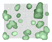
A Heat map is generally thought of as showing off hot spots or concentrations of a value or spatial object. In this case, we're showing areas where customers are located and their purchases in the same color ramp as the Thematic map, High = Light, Low = Dark. Generally speaking, the heat is created by overlaying a grid across the map and adding values to the cells based on the presence of data within them. Cells that didn't contain something are given values usually based on the distance from a cell that did. There are many ways to do this and Alteryx provides a tool to help make it easier appropriately called Heat Map.
A Thematic map (or more specifically Choropleth map) is often made by shading standard geographical areas/units based on a value for that area. These can represent many various data types across the areas they cover. This is the standard shaded map that is used the most often. It's simple to understand, people generally know the geographic units being used (zip codes in my sample map), and values can be easily seen/compared. This is likely the better option I've found in most cases but not all. Since you're providing a single value for an area this can distort your data to look like it influences the whole area shaded but depending on what went into making that value this may not be accurate, even if correct.
| Heat Map | Thematic Map |
 |
 |
Both maps were created in Alteryx using the same base data set of points.
- Mark as Read
- Mark as New
- Bookmark
- Permalink
- Notify Moderator
Hi @RussellD , this explanation was very helpful, thank you.
I am trying to build a thematic map at the state level, shaded by the count of customers in each state. I feel like this should be relatively straight forward, but I am struggling to put the pieces together. Could you share the workflow you used to generate the maps above so that I can take a look to see how you built your thematic map?
- Mark as Read
- Mark as New
- Bookmark
- Permalink
- Notify Moderator
Yes would like to know the workflow as well. Can't figure out how to show zip codes as polygons and not points.
- Mark as Read
- Mark as New
- Bookmark
- Permalink
- Notify Moderator
Also stuck with the "shading standard geographical areas/units" I would love a standard file for all US states and counties. If not a explanation on how to create the standard geographical areas. PLEASE HELP!😁
- Mark as Read
- Mark as New
- Bookmark
- Permalink
- Notify Moderator
Good morning Alteryx community,
Has anyone found the solution to shading regions (zip code, county, etc) based on the number of records in that area?
Thank you!
-
2018.3
17 -
2018.4
13 -
2019.1
18 -
2019.2
7 -
2019.3
9 -
2019.4
13 -
2020.1
22 -
2020.2
30 -
2020.3
29 -
2020.4
35 -
2021.2
52 -
2021.3
25 -
2021.4
38 -
2022.1
33 -
Alteryx Designer
9 -
Alteryx Gallery
1 -
Alteryx Server
3 -
API
29 -
Apps
40 -
AWS
11 -
Computer Vision
6 -
Configuration
108 -
Connector
136 -
Connectors
1 -
Data Investigation
14 -
Database Connection
196 -
Date Time
30 -
Designer
204 -
Desktop Automation
22 -
Developer
72 -
Documentation
27 -
Dynamic Processing
31 -
Dynamics CRM
5 -
Error
267 -
Excel
52 -
Expression
40 -
FIPS Designer
1 -
FIPS Licensing
1 -
FIPS Supportability
1 -
FTP
4 -
Fuzzy Match
6 -
Gallery Data Connections
5 -
Google
20 -
In-DB
71 -
Input
185 -
Installation
55 -
Interface
25 -
Join
25 -
Licensing
22 -
Logs
4 -
Machine Learning
4 -
Macros
93 -
Oracle
38 -
Output
110 -
Parse
23 -
Power BI
16 -
Predictive
63 -
Preparation
59 -
Prescriptive
6 -
Python
68 -
R
39 -
RegEx
14 -
Reporting
53 -
Run Command
24 -
Salesforce
25 -
Setup & Installation
1 -
Sharepoint
17 -
Spatial
53 -
SQL
48 -
Tableau
25 -
Text Mining
2 -
Tips + Tricks
94 -
Transformation
15 -
Troubleshooting
3 -
Visualytics
1
- « Previous
- Next »