Alteryx Designer Desktop Discussions
Find answers, ask questions, and share expertise about Alteryx Designer Desktop and Intelligence Suite.- Community
- :
- Community
- :
- Participate
- :
- Discussions
- :
- Designer Desktop
- :
- Re: Consistent Square Grids -- "Make Grid" tool on...
Consistent Square Grids -- "Make Grid" tool only just kind of working...
- Subscribe to RSS Feed
- Mark Topic as New
- Mark Topic as Read
- Float this Topic for Current User
- Bookmark
- Subscribe
- Mute
- Printer Friendly Page
- Mark as New
- Bookmark
- Subscribe
- Mute
- Subscribe to RSS Feed
- Permalink
- Notify Moderator
Hello Alteryx Community! Long time viewer first time poster.
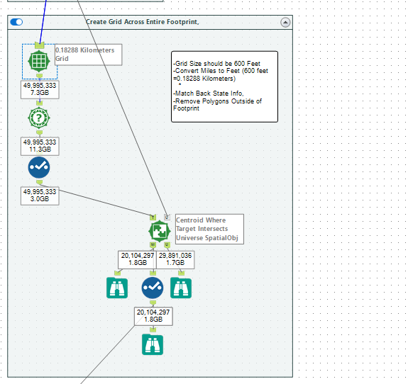
I am trying to create a single point layer (plots), spaced 600 feet apart overlayed across a 5 state footprint in the south/central US. The overall method I am using is working directionally well. However, when I measure distance between points I get measures of distance between points that don't equal the parameter's I set up in the Make Grid tool
Currently I use the Make Grid tool, set the grid length to 0.18288 km (600 feet). Then I use the Spatial Info tool to derive the centroid of each Grid cell to create the point layer. Theoretically the centroids should remain 600 feet apart across the 5 state footprint. But that is not the case.
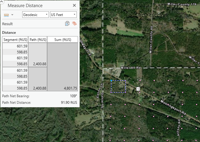
The attached image shows that the distance West to East between points turns out to be 601.59 feet, and the North to South Distance is 598.85 feet. While this is directionally accurate, I need precise distances as our methodology is heavily critiqued.
I have played with using the Grid endpoints (via spatial info tool) to then select either the First or Last point of the grid, rather then the grid centroid, and the issue remains the same.
How can I space these points exactly 600 feet apart? Is there a setting that will allow me to select distance in Feet rather than km or miles? Would I be better served to use another process? Can I adjust the distances between the spatial objects using a formula?
Solved! Go to Solution.
- Labels:
-
Bug
-
Datasets
-
Spatial Analysis

- Mark as New
- Bookmark
- Subscribe
- Mute
- Subscribe to RSS Feed
- Permalink
- Notify Moderator
- Mark as New
- Bookmark
- Subscribe
- Mute
- Subscribe to RSS Feed
- Permalink
- Notify Moderator
Hi, @WillWork4Trees and thank you, @MarqueeCrew for the introduction! Glad to help; @WillWork4Trees , you are doing everything right in your process, such as creating the grid, using Spatial Info for the centroid, then calculating distance, etc. It turns out that Alteryx actually uses a WGS84 coordinate system for all of their spatial processes, including creating grids and calculating distance. This coordinate system is simply a "grid" across a perfect sphere, which makes it easy and fast to calculate distance - however, the Earth isn't a perfect sphere, instead it's a geoid, or "squished" sphere. :)
This can result in slightly less than precise measurements in gridding and distance calculations, which is what you are finding. I have used Alteryx since 2005 for spatial analytics, and for the bulk of these analytics, it is just right - and super fast. However, whenever more exact distance measurements are required, I usually recommend (especially to GIS professionals) to use a GIS platform such as ESRI ArcGIS along with the corresponding datum or projection. Even then, if true precision is needed for legal requirements, I usually recommend using a survey team to accurately measure the distance on the ground.
There is a really good post in the Community about "How Does Alteryx Designer Handle Spatial Data?" which can be found here: How does Alteryx Designer Handle Spatial Data?
The information about the WGS84 coordinate system is near the bottom of the post, and here is a copy to make it easier to find:
"All spatial data read into Alteryx is automatically transformed to a WGS84 datum with a latitude and longitude coordinate system.
Spatial calculations in Designer are performed on a sphere with a radius between the polar and equatorial radii of the Earth. This does result in some distortion in calculations. Near the equator, distance calculations can be 0.2% smaller than their actual size, and near the poles, distance calculations can be 0.2% larger. Within the US and Europe, distance calculations are more accurate. Alteryx does not use any projected coordinates when performing spatial calculations."
I hope this helps, and please feel free to reach out to me on the Community using @Deanna ; I have been performing GIS analyses for 25 years, and am always excited to assist others in exploring spatial analytics!
P. S. GIS platforms such as ESRI ArcGIS can output shapefiles (.shp), which can be imported into Alteryx. You can also output spatial object fields in Alteryx as .shp and then import them into a GIS as well! The same goes for MapInfo .tab and other spatial formats. Using Alteryx and a GIS together can potentially speed up quite a few processes and be very beneficial!


-
AAH
1 -
AAH Welcome
2 -
Academy
24 -
ADAPT
82 -
Add column
1 -
Administration
20 -
Adobe
178 -
Advanced Analytics
1 -
Advent of Code
5 -
Alias Manager
70 -
Alteryx
1 -
Alteryx 2020.1
3 -
Alteryx Academy
3 -
Alteryx Analytics
1 -
Alteryx Analytics Hub
2 -
Alteryx Community Introduction - MSA student at CSUF
1 -
Alteryx Connect
1 -
Alteryx Designer
44 -
Alteryx Engine
1 -
Alteryx Gallery
1 -
Alteryx Hub
1 -
alteryx open source
1 -
Alteryx Post response
1 -
Alteryx Practice
134 -
Alteryx team
1 -
Alteryx Tools
1 -
AlteryxForGood
1 -
Amazon s3
139 -
AMP Engine
194 -
ANALYSTE INNOVATEUR
1 -
Analytic App Support
1 -
Analytic Apps
17 -
Analytic Apps ACT
1 -
Analytics
2 -
Analyzer
17 -
Announcement
4 -
API
1,051 -
App
1 -
App Builder
46 -
Append Fields
1 -
Apps
1,173 -
Archiving process
1 -
ARIMA
1 -
Assigning metadata to CSV
1 -
Authentication
4 -
Automatic Update
1 -
Automating
3 -
Banking
1 -
Base64Encoding
1 -
Basic Table Reporting
1 -
Batch Macro
1,286 -
Beginner
1 -
Behavior Analysis
220 -
Best Practices
2,432 -
BI + Analytics + Data Science
1 -
Book Worm
2 -
Bug
630 -
Bugs & Issues
2 -
Calgary
59 -
CASS
46 -
Cat Person
1 -
Category Documentation
1 -
Category Input Output
2 -
Certification
4 -
Chained App
239 -
Challenge
7 -
Charting
1 -
Clients
3 -
Clustering
1 -
Common Use Cases
3,418 -
Communications
1 -
Community
188 -
Computer Vision
47 -
Concatenate
1 -
Conditional Column
1 -
Conditional statement
1 -
CONNECT AND SOLVE
1 -
Connecting
6 -
Connectors
1,194 -
Content Management
8 -
Contest
6 -
Conversation Starter
17 -
copy
1 -
COVID-19
4 -
Create a new spreadsheet by using exising data set
1 -
Credential Management
3 -
Curious*Little
1 -
Custom Formula Function
1 -
Custom Tools
1,740 -
Dash Board Creation
1 -
Data Analyse
1 -
Data Analysis
2 -
Data Analytics
1 -
Data Challenge
83 -
Data Cleansing
4 -
Data Connection
1 -
Data Investigation
3,094 -
Data Load
1 -
Data Science
38 -
Database Connection
1,917 -
Database Connections
5 -
Datasets
4,629 -
Date
3 -
Date and Time
3 -
date format
2 -
Date selection
2 -
Date Time
2,912 -
Dateformat
1 -
dates
1 -
datetimeparse
2 -
Defect
2 -
Demographic Analysis
173 -
Designer
1 -
Designer Cloud
498 -
Designer Integration
60 -
Developer
3,691 -
Developer Tools
2,975 -
Discussion
2 -
Documentation
458 -
Dog Person
4 -
Download
912 -
Duplicates rows
1 -
Duplicating rows
1 -
Dynamic
1 -
Dynamic Input
1 -
Dynamic Name
1 -
Dynamic Processing
2,570 -
dynamic replace
1 -
dynamically create tables for input files
1 -
Dynamically select column from excel
1 -
Email
761 -
Email Notification
1 -
Email Tool
2 -
Embed
1 -
embedded
1 -
Engine
130 -
Enhancement
3 -
Enhancements
2 -
Error Message
1,997 -
Error Messages
6 -
ETS
1 -
Events
180 -
Excel
1 -
Excel dynamically merge
1 -
Excel Macro
1 -
Excel Users
1 -
Explorer
2 -
Expression
1,707 -
extract data
1 -
Feature Request
1 -
Filter
1 -
filter join
1 -
Financial Services
1 -
Foodie
2 -
Formula
2 -
formula or filter
1 -
Formula Tool
4 -
Formulas
2 -
Fun
4 -
Fuzzy Match
622 -
Fuzzy Matching
1 -
Gallery
600 -
General
93 -
General Suggestion
1 -
Generate Row and Multi-Row Formulas
1 -
Generate Rows
1 -
Getting Started
1 -
Google Analytics
140 -
grouping
1 -
Guidelines
11 -
Hello Everyone !
2 -
Help
4,159 -
How do I colour fields in a row based on a value in another column
1 -
How-To
1 -
Hub 20.4
2 -
I am new to Alteryx.
1 -
identifier
1 -
In Database
863 -
In-Database
1 -
Input
3,750 -
Input data
2 -
Inserting New Rows
1 -
Install
3 -
Installation
307 -
Interface
2 -
Interface Tools
1,663 -
Introduction
5 -
Iterative Macro
954 -
Jira connector
1 -
Join
1,753 -
knowledge base
1 -
Licenses
1 -
Licensing
212 -
List Runner
1 -
Loaders
12 -
Loaders SDK
1 -
Location Optimizer
53 -
Lookup
1 -
Machine Learning
232 -
Macro
2 -
Macros
2,519 -
Mapping
1 -
Marketo
12 -
Marketplace
5 -
matching
1 -
Merging
1 -
MongoDB
67 -
Multiple variable creation
1 -
MultiRowFormula
1 -
Need assistance
1 -
need help :How find a specific string in the all the column of excel and return that clmn
1 -
Need help on Formula Tool
1 -
network
1 -
News
1 -
None of your Business
1 -
Numeric values not appearing
1 -
ODBC
1 -
Off-Topic
14 -
Office of Finance
1 -
Oil & Gas
1 -
Optimization
656 -
Output
4,563 -
Output Data
1 -
package
1 -
Parse
2,118 -
Pattern Matching
1 -
People Person
6 -
percentiles
1 -
Power BI
198 -
practice exercises
1 -
Predictive
2 -
Predictive Analysis
828 -
Predictive Analytics
1 -
Preparation
4,670 -
Prescriptive Analytics
186 -
Publish
230 -
Publishing
2 -
Python
734 -
Qlik
36 -
quartiles
1 -
query editor
1 -
Question
18 -
Questions
1 -
R Tool
455 -
refresh issue
1 -
RegEx
2,127 -
Remove column
1 -
Reporting
2,139 -
Resource
15 -
RestAPI
1 -
Role Management
3 -
Run Command
503 -
Run Workflows
10 -
Runtime
1 -
Salesforce
247 -
Sampling
1 -
Schedule Workflows
3 -
Scheduler
374 -
Scientist
1 -
Search
3 -
Search Feedback
20 -
Server
531 -
Settings
762 -
Setup & Configuration
47 -
Sharepoint
474 -
Sharing
2 -
Sharing & Reuse
1 -
Snowflake
1 -
Spatial
1 -
Spatial Analysis
563 -
Student
9 -
Styling Issue
1 -
Subtotal
1 -
System Administration
1 -
Tableau
469 -
Tables
1 -
Technology
1 -
Text Mining
418 -
Thumbnail
1 -
Thursday Thought
10 -
Time Series
398 -
Time Series Forecasting
1 -
Tips and Tricks
3,816 -
Tool Improvement
1 -
Topic of Interest
40 -
Transformation
3,267 -
Transforming
3 -
Transpose
1 -
Truncating number from a string
1 -
Twitter
24 -
Udacity
85 -
Unique
2 -
Unsure on approach
1 -
Update
1 -
Updates
2 -
Upgrades
1 -
URL
1 -
Use Cases
1 -
User Interface
21 -
User Management
4 -
Video
2 -
VideoID
1 -
Vlookup
1 -
Weekly Challenge
1 -
Weibull Distribution Weibull.Dist
1 -
Word count
1 -
Workflow
8,564 -
Workflows
1 -
YearFrac
1 -
YouTube
1 -
YTD and QTD
1
- « Previous
- Next »