Alteryx Designer Desktop Ideas
Share your Designer Desktop product ideas - we're listening!Submitting an Idea?
Be sure to review our Idea Submission Guidelines for more information!
Submission Guidelines- Community
- :
- Community
- :
- Participate
- :
- Ideas
- :
- Designer Desktop: New Ideas
Featured Ideas
Hello,
After used the new "Image Recognition Tool" a few days, I think you could improve it :
> by adding the dimensional constraints in front of each of the pre-trained models,
> by adding a true tool to divide the training data correctly (in order to have an equivalent number of images for each of the labels)
> at least, allow the tool to use black & white images (I wanted to test it on the MNIST, but the tool tells me that it necessarily needs RGB images) ?
Question : do you in the future allow the user to choose between CPU or GPU usage ?
In any case, thank you again for this new tool, it is certainly perfectible, but very simple to use, and I sincerely think that it will allow a greater number of people to understand the many use cases made possible thanks to image recognition.
Thank you again
Kévin VANCAPPEL (France ;-))
Thank you again.
Kévin VANCAPPEL
Hi!
Just thought up a simple improvement to the US Geocoder macro that could potentially speed up the results. I'm doing an analysis on some technician data where they visit the same locations over & over again. I'm doing a full year analysis (200k + records) & the geocoder takes a bit to churn thru that much data. In the case of my data though, it's the same addresses over & over again & the geocoder will go thru each one individually.
What I did in my process & could be added to the macro is to put a unique tool into the process based off address, city, state, zip, then Geocode the reduced list, then simply join back to the original data stream using a join based off the address, city, state, zip fields (or use record id tool to created a unique process id to join off).
In my case, the 200k records were reduced to 25k, which Alteryx completed in under a minute, then joined back so my output was still the 200k records (all geocoded now).
Not everyone will have this many duplicates, but I'd bet most data has a few, & every little bit of time savings helps when management is waiting on the results haha!
-
Category Address
-
Category Macros
-
Category Spatial
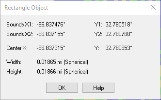
Ability to ‘name’ the point created in the “Create Points” tool.
Instead of sticking a select tool after it to rename it from ‘centroid’ to Starting Location or Store location or whatever.
-
Category Spatial
-
Location Intelligence
When a user wants to use the find nearest to say find the nearest within 200 miles the dropdown stops at 100.
Similar if they want a number in between IE 15 the interface is not intuitive.
While you can just type the number in the interface doesn't look like you are able to.
Simply adding a "Custom" selection at the bottom would make this much more intuitive.
-
Category Spatial
-
Location Intelligence
Alteryx currently shows 100% in the profiling of spatial fields in the results window, regardless of if there are rows with missing spatial features. I opened a ticket about this & was told it is expected behavior.
Therefore, I submit the idea that the profiling for spatial fields should give an accurate profile of the field, & if there are nulls in the field, it should identify that column isn't 100% OK and show the % of records that have null values, like the profiling does for every other column in workflows.

Thank you!
Variations of this concept have been discussed in community since 2016. Alteryx is awesome right up to the point where we need to see our files in ArcGis Pro or ArcGis Online. The shapefile is painful. We have to rename every field in ArcGis Pro with over about 10 characters because all of the field names are truncated. Yes- you can make a shapefile and a text file from Alteryx, then join in ArcGis Pro, but its a million clicks and its not a good solution. Shapefiles are limited to 2GB, which is not great either, but the field truncation is super frustrating.
In fact- rather than making an output file, I bet it would be easier to make a tool that connects to the ESRI API. Everyone gets stuck on passing the spatial field because its like a giant text field with all of the instructions to create a point, line, or polygon.
Does anyone have the software engineering chops to make this happen? :)
-
Category Spatial
-
Location Intelligence
If i draw a line that crosses the pacific ocean, the path is split in half, and connected by a line that goes over the Atlantic..
This isn't just cosmetic.. if i intersect this object with another polygon, it will show that the two objects interact even though they should not.. The only way i can fix this is to manually divide my polyline into two objects where they cross the pacific ocean.
Please fix this.

-
Category Spatial
-
Location Intelligence
I'm plotting ship's routes on a map by using the Poly-Build tool to create a Sequence Polyline, the source field is a daily snapshot of a ship's position, the sequence is the date. This works well until the ship goes off the map, i.e heading west in the North Pacific to Japan. Rather than wrapping the line around the world, it draws an ugly line across the map:

I've seen some super clever WFs on here where people have manipulated coordinates to stop this happening, but rather than me having to do that (and probably getting it wrong), could you make the Poly-Build tool map sensitive?
-
Category Spatial
-
Location Intelligence
I would like the capability to spatially intersect vector data over raster based geographic information. I have to go back and forth between Alteryx and ArcGIS to perform the zonal statistics and then back to Alteryx to complete the data analysis.
-
Category Spatial
-
Location Intelligence
The 'Make Grid' tool appears to occasionally scramble the order as shown by the 'Grid Names' I have highlighted. As its almost in order it gave a false sense of looking as though it was designed to be in 'GridName' order, so it was not obvious that it needed to be sorted. To make the tool more intuitive it may make sense to give the option to sort by 'GridName' or just do it by default.


Thanks,
Ira
-
Category Spatial
-
Location Intelligence
Do put an option to take any distance.

it sure have case that we do not care the distance.
same go to other spatial tool have similar setting.
-
Category Spatial
-
Location Intelligence
-
Category Spatial
-
Location Intelligence
The guide line of Shape File is below. They recommend that you use only letters and numbers.
"Spaces and certain characters are not supported in field names. Special characters include hyphens such as in x-coordinate and y-coordinate; parentheses; brackets; and symbols such as $, %, and #. Essentially, eliminate anything that is not alphanumeric or an underscore."
But many GIS tools can read and write 2 byte field name at Shape File.
(e.g. QGIS https://qgis.org/en/site/index.html)
And Esri Japan says Shape file can use 2 byte field name.
https://www.esrij.com/gis-guide/esri-dataformat/shapefile/
We want to use 2 byte field name at Shape File on Alteryx Designer.
(e.g. UTF-8 , Shift-JIS )
Thanks,
Kajitani
-
Category Input Output
-
Category Spatial
-
Data Connectors
-
Location Intelligence
When you use Create Points tool - you then almost always need to use a Select tool to rename that point.
Can we please add a single text field to the Create Points tool - which would then allow us to create and name a point in one step?

-
Category Spatial
-
Location Intelligence
In GIS, spatial data is regularly stored/transmitted as text. With this comes metadata, including the projection used.
Example Issue: When extracting data from ESRI's ArcGIS REST Directories, the projection can be extracted from the information, but must be manually defined in the Make Points Tool. If you are trying to compile data from several different sources, all using different projections, you cannot automate the process.
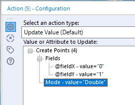
Suggested Solution: Add WKT to macro interface configuration options so that an Action Interface Tool can update the Create Points Tool.
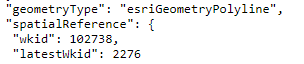
Attachments:
JSON extract.png - This is a screenshot of the spatial reference metadata in a JSON formatted query from an ArcGIS REST Directory.
action tool.png - Current configuration options for Create Points Tool in the Action Interface Tool.
-
Category Interface
-
Category Macros
-
Category Spatial
-
Desktop Experience
When calculating distance from a single point (or a list of points) to many other points, it can require a lot of processing time to append the single point into the same table as the multiple points (especially with very large datasets). Seems it would be more efficient to allow the single point as in input to the distance tool and bypass the timely append step.
-
Category Spatial
-
Location Intelligence
Hi, I would like the ability to hover over a point/polygon on a Browse tool that displays geospatial data and be provided with some information on the data that isn’t currently offered. Namely, I would like the ability to hover over a point/centroid and have a bubble (a.k.a. tool tip) pop up displaying the exact coordinates of that datum, the row ID and some other unique identifying information (e.g. name, store number, etc). Other geospatial tools provide this functionality. See below:
Google Maps:

Alteryx:

And by the way, I realize Alteryx is not Google Maps, but as a data “consumer” or “interactor”, I think it’s just human nature for people to want them to “feel” the same. Something to strive for, at least.
I would also like the ability to click a datum displayed on the browse tool and have it highlight the row on the Results pane. The clicking functionality works going from the Results pane to the Browse tool, but not the other way.
Thanks! Kurt
-
Category Spatial
-
Location Intelligence
First: Including mapbox in 2019.4 is GREAT!
That said, one of the great features of mapbox is the ability to customize your own map layers.
It would be great if this was an option to use a custom map as the alteryx reference map similar to what is available within tableau. We in our organization have several custom map styles built with mapbox and I'd love to use them as a reference in the report map tool, or any other scenario where maps become useful.
-
Category Spatial
-
Location Intelligence
In Designer user settings, you have the option to set a default dataset for the reference base map. This is a fantastic feature when working with spatial objects. My suggestion is that this feature should persist when viewing .yxdb files outside of Designer workflows.
When I'm browsing a folder of .yxdb files that contain spatial objects, clicking on those files opens a viewing/browse window outside of Designer. Unfortunately, the base reference map setting does not currently transfer and must be reelected each time a file is opened. I would like suggest that this setting persist in this situation.
-
Category Spatial
-
Location Intelligence
I appreciate being able to write to an ESRI File GeoDatabase. It would be even better if in the process of writing to an ESRI File GeoDatabase I could identify fields to index and have them indexed when writing to the File GeoDatabse. Currently I have to add the index in ArcGIS after the fact. Writing to an ESRI File GeoDatabase currently adds a spatial index automatically, but I'm talking about an attribute index here.
-
Category Input Output
-
Category Spatial
-
Data Connectors
-
Location Intelligence
When building an analytic app which uses a Map Input, please enable Interface tool functionality which would allow the app user to change the base map (roads, imagery, etc.) within the app map interface. Currently I believe the only way to accommodate different base maps in an app is to configure multiple Map Inputs – one for each base map. The resulting map interface duplication clutters up the app and opens the door for configuration errors.

-
Category Apps
-
Category Interface
-
Category Spatial
-
Desktop Experience
- New Idea 207
- Accepting Votes 1,838
- Comments Requested 25
- Under Review 149
- Accepted 55
- Ongoing 7
- Coming Soon 8
- Implemented 473
- Not Planned 123
- Revisit 68
- Partner Dependent 4
- Inactive 674
-
Admin Settings
19 -
AMP Engine
27 -
API
11 -
API SDK
217 -
Category Address
13 -
Category Apps
111 -
Category Behavior Analysis
5 -
Category Calgary
21 -
Category Connectors
239 -
Category Data Investigation
75 -
Category Demographic Analysis
2 -
Category Developer
206 -
Category Documentation
77 -
Category In Database
212 -
Category Input Output
631 -
Category Interface
236 -
Category Join
101 -
Category Machine Learning
3 -
Category Macros
153 -
Category Parse
75 -
Category Predictive
76 -
Category Preparation
384 -
Category Prescriptive
1 -
Category Reporting
198 -
Category Spatial
80 -
Category Text Mining
23 -
Category Time Series
22 -
Category Transform
87 -
Configuration
1 -
Data Connectors
948 -
Desktop Experience
1,493 -
Documentation
64 -
Engine
121 -
Enhancement
274 -
Feature Request
212 -
General
307 -
General Suggestion
4 -
Insights Dataset
2 -
Installation
24 -
Licenses and Activation
15 -
Licensing
10 -
Localization
8 -
Location Intelligence
79 -
Machine Learning
13 -
New Request
177 -
New Tool
32 -
Permissions
1 -
Runtime
28 -
Scheduler
21 -
SDK
10 -
Setup & Configuration
58 -
Tool Improvement
210 -
User Experience Design
165 -
User Settings
73 -
UX
220 -
XML
7
- « Previous
- Next »
- vijayguru on: YXDB SQL Tool to fetch the required data
- Fabrice_P on: Hide/Unhide password button
- cjaneczko on: Adjustable Delay for Control Containers
-
 Watermark
on:
Dynamic Input: Check box to include a field with D...
Watermark
on:
Dynamic Input: Check box to include a field with D...
- aatalai on: cross tab special characters
- KamenRider on: Expand Character Limit of Email Fields to >254
- TimN on: When activate license key, display more informatio...
- simonaubert_bd on: Supporting QVDs
- simonaubert_bd on: In database : documentation for SQL field types ve...
- guth05 on: Search for Tool ID within a workflow