Alteryx Designer Desktop Knowledge Base
Definitive answers from Designer Desktop experts.- Community
- :
- Community
- :
- Support
- :
- Knowledge
- :
- Designer Desktop
- :
- Combine Spatial Fields Using a Summarize Tool
Combine Spatial Fields Using a Summarize Tool
- Subscribe to RSS Feed
- Mark as New
- Mark as Read
- Bookmark
- Subscribe
- Printer Friendly Page
- Notify Moderator
on 06-29-2016 08:28 AM - edited on 07-27-2021 11:39 PM by APIUserOpsDM
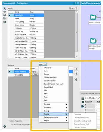
Spatial functions in the Alteryx Designer are not limited to only those tools in the Spatial tool palette. The Summarize tool, for example, is able to perform spatial functions, such as Combine and Intersect, and create spatial objects.
While these capabilities are not unique to the Summarize tool (other Spatial tools perform these same processes), the fact that spatial functionality is embedded in the Summarize tool allows for additional capabilities beyond those of the Spatial tools. One such function is “Group By”, which is not incorporated into the Spatial tools. The Summarize tool, however, allows a user to “group”, or aggregate, smaller polygons into larger geographies.
The attached workflow demonstrates this ability by aggregating the counties in Texas into polygons that represent the state’s Public Health Management Regions (PHMRs). The first input contains shapefiles of each of the Texas counties. The second lists the 11 PHMRs and the counties associated with them. After Joining the two inputs, the data is Summarized, Grouping by PHMR and then Spatially Combining the counties. As a result larger polygons of the Public Health Management Regions can be created by Summarizing the data by first Grouping by Region then Spatially Combining the County polygons. The result is 11 polygons, one for each of the PHMRs.
From individual counties...............................................................................to regions!
For more ideas on the Summarize tool's spatial capabilities, see this blog post by JimS!
-
2018.3
17 -
2018.4
13 -
2019.1
18 -
2019.2
7 -
2019.3
9 -
2019.4
13 -
2020.1
22 -
2020.2
30 -
2020.3
29 -
2020.4
35 -
2021.2
52 -
2021.3
25 -
2021.4
38 -
2022.1
33 -
Alteryx Designer
9 -
Alteryx Gallery
1 -
Alteryx Server
3 -
API
29 -
Apps
40 -
AWS
11 -
Computer Vision
6 -
Configuration
108 -
Connector
136 -
Connectors
1 -
Data Investigation
14 -
Database Connection
196 -
Date Time
30 -
Designer
204 -
Desktop Automation
22 -
Developer
72 -
Documentation
27 -
Dynamic Processing
31 -
Dynamics CRM
5 -
Error
267 -
Excel
52 -
Expression
40 -
FIPS Designer
1 -
FIPS Licensing
1 -
FIPS Supportability
1 -
FTP
4 -
Fuzzy Match
6 -
Gallery Data Connections
5 -
Google
20 -
In-DB
71 -
Input
185 -
Installation
55 -
Interface
25 -
Join
25 -
Licensing
22 -
Logs
4 -
Machine Learning
4 -
Macros
93 -
Oracle
38 -
Output
110 -
Parse
23 -
Power BI
16 -
Predictive
63 -
Preparation
59 -
Prescriptive
6 -
Python
68 -
R
39 -
RegEx
14 -
Reporting
53 -
Run Command
24 -
Salesforce
25 -
Setup & Installation
1 -
Sharepoint
17 -
Spatial
53 -
SQL
48 -
Tableau
25 -
Text Mining
2 -
Tips + Tricks
94 -
Transformation
15 -
Troubleshooting
3 -
Visualytics
1
- « Previous
- Next »

